If i see an image on the radar similar to the above anywhere near our location, then we really will have hit the jackpot.
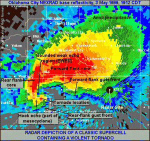
What you can see above is known as a ‘hook echo’ and is the telltale sign that a tornado is imminent or already on the ground. The one above is from the F5 tornado in Oklahoma city in 1999, so in all likelihood what we will see is unlikely to be as clearly defined as the image above. What is does show is how you can get pretty close to the action while avoiding the worst of the rain and hail.
The place you want to be in is the grey part of the hook, somewhere to the right of the tornado location and ideally, lets face it, out of the path of the tornado itself. (The storm will likely be heading in an east/north east direction)
That grey area is the inflow area, which basically means that it contains the warm moist air that fuels the storm. This air wraps in around the updraft and the cloud base is usually rain-free with good visibility. You always have to be careful though, as sometimes the bottom left part of the red area, known as the ‘Rear Flank Downdraft’ can often wrap right round the tornado, bringing strong straight-line winds, rain and hail.
The worst place to be is anywhere in the bright red area because not only are you going to be pelted with hail up to and above the size of cricket balls, but you won’t be able to see the tornado heading in your general direction.
Our plan will be to always have an escape route, which will be a road that can get us south or southeast if things start to get a bit hairy